Cumbemayo is an archaeological and landscape site about 20 km south-west of Cajamarca, at roughly 3,500 m. Its two draws are a long, precisely cut pre-Inca water channel and the Frailones, a field of weathered volcanic pillars. Allow half a day from town, go in the morning, wear warm and waterproof layers, and take it slowly because the altitude is higher than in Cajamarca itself.
Map
What Cumbemayo is
Cumbemayo (also written Cumbe Mayo) is a high plateau of volcanic rock in the hills south-west of Cajamarca. The name is usually explained as "narrow river" in the local Quechua, which describes the main feature well: a thin, straight watercourse cut into the stone, running across the hillside.
The site is a mix of three things. There is an ancient channel, a field of tall rock pillars known as the Frailones, and a scatter of caves, shelters and carved rocks with petroglyphs. None of it looks like an Inca citadel, and nothing here has the tidy plazas and terraces of the southern Andes. That is part of the appeal. Cumbemayo is a place where the landscape and the stonework are hard to separate, and the walk between the parts is as much of the visit as the parts themselves.
It sits at about 3,500 m, around 800 m above Cajamarca, so the air is colder and thinner and the ground is open grassland and rock rather than farmland.
A very old water channel
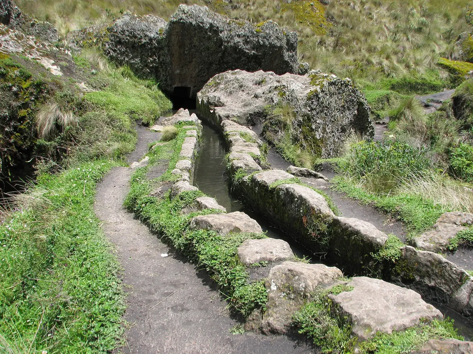
The channel is the reason archaeologists take the site seriously. It is a canal cut into the volcanic stone to carry water from the high ground across the divide towards the Cajamarca side, with a long, nearly straight run and sharp angular turns. Sources commonly date it to around 1500 BC, long before the Incas, which makes it one of the older large engineering works in the Peruvian Andes, though the exact age and the full length quoted vary between sources.
The most puzzling feature is the zigzag sections, where the channel turns at sharp angles. A common explanation is that the angles slow the flow and reduce erosion of the stone, but this is an interpretation. What a visitor can see without any theory is how clean the cut is, how consistently the line holds across uneven ground, and how much labour it took in a landscape with no iron tools.
Stone steps and a carved ceremonial-looking block along the path add to the sense that water here was more than a utility. Water still runs in places, depending on the season.
The Frailones stone forest
Beside the channel stands the Frailones, a group of volcanic pillars shaped by wind and rain. The word means "friars", and the name comes from the resemblance of some of the shapes to hooded figures filing along the hillside. Some pillars are said to reach about 18 m, though most visitors will simply notice that the tallest are several times human height.
The best way to see them is to walk slowly among them and look at the surface, which is pitted, layered and covered in lichen. The rock is not carved by people; it is a natural formation, and the guides' stories about faces and animals are a matter of imagination. A few shelters and cliffs in the area carry petroglyphs that have been compared to those of the Chavín tradition, though nobody has read them, and interpretations should be treated as hypotheses.
The paths wander between the rocks, so it is easy to go off the main line. Keep to the marked route and avoid climbing on the formations, which are fragile.
Getting there from Cajamarca
Cumbemayo is roughly 20 km from Cajamarca by road, and the journey takes a bit under an hour each way depending on the vehicle and the condition of the road. The standard way to visit is a half-day tour from town, which is usually the simplest option since the operator deals with the road, the timing and a guide who can explain the site.
Going alone is also possible with a taxi hired for the round trip. Agree the price, the waiting time and the return in advance, because there is little else on the plateau, and a driver who leaves you stranded would be a real problem. See taxis and apps for how to approach this in general.
A few people walk up from Cajamarca on foot or by bike. This is a serious climb at altitude, and it is better suited to people who are already acclimatised and well equipped. Check current road and access conditions with your hotel before choosing.
How long and when to go
Plan about half a day in total, including the drive. The walk through the site itself, with stops at the channel and the Frailones, usually takes two to three hours at an easy pace, depending on how far the route you follow extends and whether a guide leads it. Check the length of your own route with the operator beforehand.
Morning is the best time. Skies are usually clearer, and cloud and rain tend to build later in the day on the plateau. The dry season, roughly May to September, is the most reliable for dry paths and views, while the wet months, roughly December to March, make the ground slippery and the weather unpredictable, although the grass is greener.
Opening hours and entrance arrangements change, so confirm them locally. Tour operators in Cajamarca usually know the current situation. If you travel in a busy holiday week, see when to book for how to plan ahead.
Altitude, weather and clothing
At about 3,500 m, Cumbemayo is noticeably higher than Cajamarca at roughly 2,700 m, and the climb in a short drive can bring a mild headache or breathlessness, especially if you have just arrived from the coast. Walk slowly, drink water, and read altitude sickness if you are unsure. A rest day in town before the excursion helps.
The weather is changeable. Sun can be strong, wind cold, and showers sudden. Wear layers, a waterproof jacket, a hat, sun protection and shoes with grip, since the rock and the paths are slippery when wet. A small daypack with water and a snack is enough. The packing list covers the basics for highland days.
The site is exposed, and there are few places to shelter from rain apart from rock overhangs. If the weather turns bad, it is sensible to shorten the walk rather than push on.
Who it suits and what to combine it with
Cumbemayo suits travellers who like landscape and early archaeology more than monuments. It works well for walkers, photographers and anyone curious about how people managed water in the Andes. It is less satisfying for those expecting an Inca ruin, and a guide helps because the stonework is easy to walk past without understanding.
The usual pairing is the morning at Cumbemayo and an afternoon in town for the plaza and the sights described on the Cajamarca page, or the thermal baths. Two nights in Cajamarca fit both comfortably.
For a longer trip, Cajamarca sits between the coast and the cloud forest. The northern itinerary shows how it connects with Trujillo, Chiclayo and Chachapoyas, and the regional cooking is described in eating in the north. For general precautions on the road see travel safety.
Where to sleep
-
Find hotels
Cajamarca
Colonial highland town with thermal baths nearby
Frequently asked questions
How far is Cumbemayo from Cajamarca?
About 20 km south-west of the city, a drive of a bit under an hour. Most visitors go on a half-day tour or in a taxi that waits.
How old is the Cumbemayo aqueduct?
It is commonly dated to around 1500 BC, so it is much older than the Incas. The exact age and the length of the channel vary between sources, and archaeologists still debate details.
What are the Frailones?
They are natural volcanic pillars shaped by wind and rain, named "friars" because some resemble hooded figures. They are not carved by people.
Is Cumbemayo hard to walk?
The paths are not technically difficult, but the ground is uneven and slippery after rain, and the altitude of about 3,500 m makes even easy walking tiring. Go slowly and bring water.
Can I visit Cumbemayo independently?
Yes, with a taxi hired for the round trip, but agree the waiting time and price first. A guided tour from town is simpler and gives context for the stonework. See taxis and apps.
What should I wear at Cumbemayo?
Layers, a waterproof jacket, a hat, sun protection and shoes with grip. Weather changes quickly on the plateau, and it is colder than in Cajamarca.
Is Cumbemayo worth it if I am short of time?
If you have two nights in Cajamarca, yes: it is the most distinctive thing outside town. If you have only a few hours, the town sights and the baths are easier, so consider flying in to save road time.