The Incas adapted their engineering to steep mountains: stepped agricultural terraces, a road network of tens of thousands of kilometres known as the Qhapaq Ñan, tightly fitted stone walls that resist earthquakes, rope suspension bridges, stone water channels and the quipu, a knotted-cord record system. Good places to see them are Ollantaytambo, Moray, Sacsayhuamán, the Inca Trail and the Sacred Valley.
Terraces: farming on slopes
The stepped platforms visible all over the Andes are called andenes. Each terrace is held by a stone retaining wall, filled with layers of gravel, sand and soil to drain water, and topped with fertile earth, often brought from lower valleys. They created flat land, limited erosion and made use of the sun's warmth stored in stone.
Terraces also worked as an agricultural laboratory. Because each level has a slightly different temperature and moisture, farmers could grow many crops and varieties of potato and maize. Many terraces near Pisac, Ollantaytambo and in the Colca Valley are still farmed today, some of them with Inca or pre-Inca walls. When walking on them, stay on marked paths, as stepping on walls damages a structure that has lasted centuries.
The Qhapaq Ñan road network
The Qhapaq Ñan, the "royal road", linked Cusco with the four corners of the empire. Two main axes ran along the coast and the highlands, with countless side roads. The system is usually estimated at around 30,000 km, and a part of it was inscribed by UNESCO as a World Heritage property in 2014 together with other Andean countries.
The roads were paved or cut into stone, with steps on slopes, drains and retaining walls. Way stations called tambos stood at regular intervals, and relay runners called chasqui carried messages, probably covering long distances in a few days. Without wheeled vehicles or horses, the roads served walkers and llama trains. The Inca Trail is the most famous surviving section, and the Sacred Valley holds several more.
Stonework without mortar
Inca masons shaped stone blocks to fit so closely that a knife blade cannot pass between them. The finest masonry, in temples and royal buildings, uses polygonal blocks with many angles, such as those seen in Cusco's Hatun Rumiyoc street. Simpler walls use rough stones in clay mortar.
The walls often lean slightly inwards, doors and niches are trapezoidal and corners are interlocked, features that help buildings withstand earthquakes, which are common in Peru. The huge stones of Sacsayhuamán, some weighing many tonnes, were quarried nearby and moved by large work teams using ramps, ropes and levers. Claims about lost technologies or extraterrestrial help are not supported by evidence, and archaeologists have found quarries, abandoned stones and tools. The remaining question is mostly how long the work took.
Bridges and rope technology
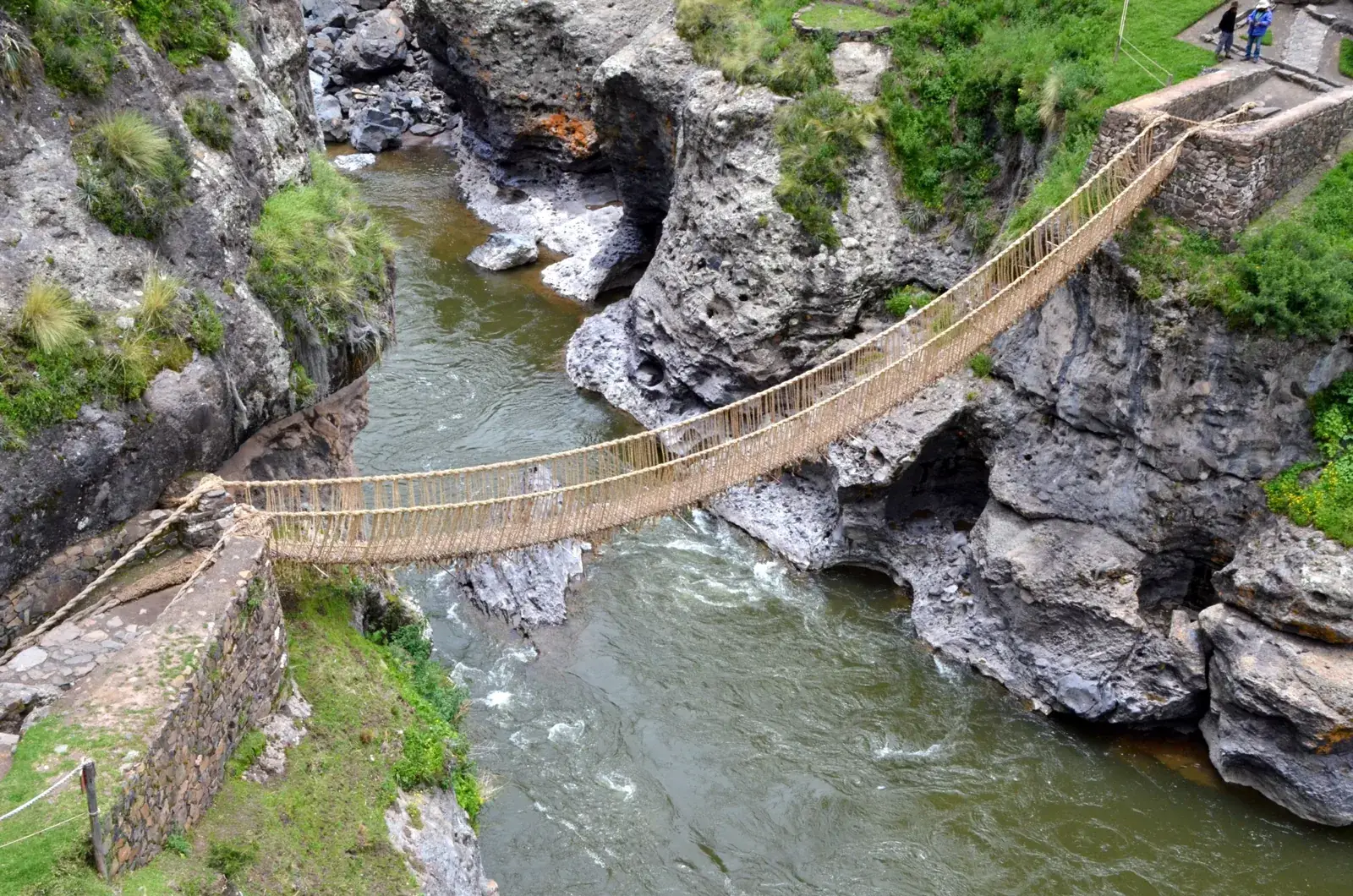
Without wheels or iron, the Incas relied heavily on fibre. Ropes twisted from grass and agave were used to haul stone, and the same material was woven into suspension bridges across gorges. The best known, the Q'eswachaka bridge over the Apurímac river, is rebuilt every June by neighbouring communities using traditional methods, an event of living tradition recognised by UNESCO as intangible heritage.
Inca bridges, usually spanning gorges of 30 to 40 metres or more, were maintained by communities as part of labour service. The Spanish were astonished by them and noted that horses could cross. Few historic bridges survive, because fibre decays and the bridges needed regular renewal, but the method continues in a handful of places.
Water and sacred fountains
Water was central to Inca engineering and religion. Canals carried it from springs and glacier melt to terraces and cities, and in Cusco the streams were channelled in stone. At Ollantaytambo, water still runs through stone channels in the town, and the royal bath at Tambomachay and the fountains of Machu Picchu show how springs were turned into ceremonial features.
At Machu Picchu a series of sixteen fountains is fed by a canal from a spring above the site. Drainage was equally important, since the citadel receives heavy rain: hidden channels, gravel layers and terraces keep the buildings from sliding. Much of the engineering at the site is under the surface. Read Ollantaytambo for a town where Inca water management is still working.
Moray: an agricultural experiment?
Near Maras, in the Sacred Valley, Moray is a group of circular depressions lined with concentric terraces, the largest about 30 metres deep. Measurements have shown a difference in temperature between the top and bottom of several degrees, which led to the popular idea that the Incas used it to test crops at different altitudes.
This is a plausible theory but not proven, and some researchers think the site may have had ritual or other functions as well. Irrigation channels reach each level, and the terraces are impressive from any angle. See Moray for visiting details, and combine it with the nearby Maras salt pans, where thousands of small pools are still worked by local families.
The quipu: keeping records in cords
The Incas had no known written script, but they kept accounts in quipus, devices of coloured cords on which knots in different positions represent numbers. Specialists called quipucamayocs recorded harvests, tribute, population counts and probably other information.
Numerical meaning is largely understood, based on a decimal system, but whether quipus also recorded narratives or language is still debated. Researchers continue to study surviving examples, which are held in museums in Peru and abroad. Some communities in the Andes still use knotted cords for tallying. Seeing a quipu in a museum, together with the engineering sites, gives a fuller idea of how an empire without writing or money managed its resources.
Frequently asked questions
How did the Incas move such large stones?
Teams of workers used ropes, ramps, wooden levers and rollers, and shaped stones with harder stone hammers rather than iron tools. Quarry sites with unfinished blocks show the process.
How long is the Inca road system?
The Qhapaq Ñan is usually estimated at around 30,000 km across six countries. The exact figure depends on whether branch roads and local paths are counted.
Why do Inca walls survive earthquakes?
The stones are tightly fitted, slightly inclined inwards and interlocked at corners, which allows the structure to shift and settle rather than collapse. Many Spanish colonial walls built on top were damaged in earthquakes while the Inca base remained.
Is Moray open to visitors?
Yes, as a stop in the Sacred Valley, usually reached on a half-day tour or by taxi from Maras or Urubamba. Check the ticket in advance, since Moray is normally included in the partial tourist ticket for the region.
Did the Incas use iron or the wheel?
No. They worked in stone, bronze, gold and silver, and used the wheel only possibly in toys. Llamas carried loads along the roads.
Can I walk on original Inca roads?
Yes. The Inca Trail, the Salkantay and Lares routes and many local paths include paved original sections. Walk on them with care and do not move stones.
What is the Q'eswachaka bridge?
A rope suspension bridge over the Apurímac river in Cusco region, renewed every June using grass rope by local communities. Visits are possible from Cusco, but the renewal days are very busy.