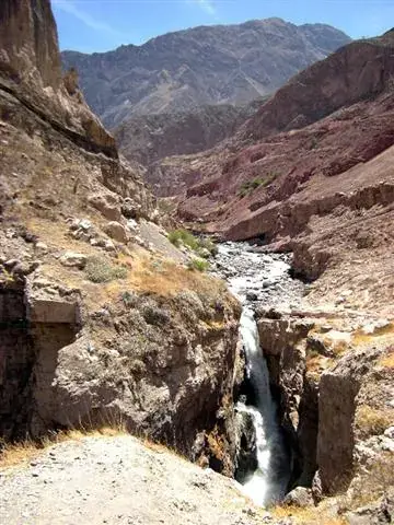
The Sipia Falls are a waterfall of about 150 m on the Cotahuasi river, in the Arequipa region, and the most famous single sight of the canyon. They lie roughly an hour's walk or a short drive from Cotahuasi town, so they fit comfortably into half a day. The river is fullest in the wet months and the access road is most reliable in the dry season, so choose the season according to what matters to you, and confirm the walking arrangements locally.
Map
What the Sipia Falls are
The Sipia Falls (Catarata de Sipia) are a single long drop of the Cotahuasi river, in the upper part of the canyon of the same name, in the Arequipa region of southern Peru. The usual figure quoted for the height is about 150 m, which makes them one of the tallest waterfalls in the country that a visitor can reach without a major expedition. Some descriptions speak of a cascade in several steps rather than one clean fall, and heights quoted by different sources vary a little, so treat the number as an approximation.
What makes the place memorable is not only the height but the setting. The river runs through a dry, rocky landscape and then throws itself into a narrow gorge, so the contrast between bare slopes and a column of white water is sharp. A fine spray drifts over the viewing area on windy days.
The falls are the headline sight of the Cotahuasi Canyon, where they are usually mentioned first, and they have no real equivalent in the more visited Colca Canyon, which is known for condors and terraces instead.
Why they matter to the canyon
Cotahuasi is a place with very few fixed attractions, and the falls are the one that nearly every visitor has heard of before arriving. For the local villages they are also a natural landmark that gives travellers a reason to stay a night or two, which supports small guesthouses, drivers and guides in the area.
The canyon around them belongs to a protected landscape reserve, so the scenery has stayed largely free of development. There is no ticket office, shop or paved promenade of the kind found at better-known Peruvian sights, and visitors should expect a simple, rural viewpoint rather than a managed site.
The river that feeds the falls is the same one that carves the deepest parts of the canyon downstream. Its flow varies strongly through the year, so what you see in March can differ a great deal from what you see in August. That seasonal swing is the single most useful thing to understand when you plan the visit.
Getting there from Cotahuasi town
Nearly all visits start in the town of Cotahuasi, the main base of the canyon, which lies at roughly 2,600 m. From the town, the falls are reached along a rural road that follows the river. Descriptions of the distance differ between sources, with figures of around 10 km quoted, and the walking time from the town is often given as about an hour for those who prefer to go on foot. Because these numbers vary, ask at your lodging how people currently do it.
The practical options are three. You can go by hired vehicle or shared transport as far as the end of the road and then walk the last stretch, which is usually described as a few hundred metres. You can walk the whole way from town on a fine morning, which suits people who are already acclimatised. Or you can join a local guide who arranges transport and timing.
Reaching Cotahuasi itself is the harder part, since the journey from Arequipa takes most of a day. See Cotahuasi Canyon for the approach and Arequipa for the usual starting point.
What the visit is like
A typical visit has three parts: the approach by road or track, the short final walk, and the time at the viewpoint. At the end of the walk there is a view of the falls from the front, with the river noise filling the gorge. How close you can get depends on the layout of the paths and the water level, and some paths may be wet or muddy.
Plan on one to two hours at the site in addition to the travel, which is enough for photographs and a rest. There is usually little to buy on the spot, so carry water and a snack. Depending on the time of year, a small number of local people may offer simple food or drinks nearby, but do not count on it.
The surrounding walls are steep and loose in places. Stay on the clear paths, keep children close, and do not approach the edge of the pool or climb the rocks beside the water. Spray makes surfaces slippery, and a fall in a remote place would be hard to deal with.
The light is best when the sun is high enough to reach into the gorge, which tends to mean late morning. Early in the day the falls can be partly in shade.
Best season and time of day
The wet season, roughly November to March, brings the largest volume of water and the most dramatic falls, but also the greatest risk of landslides on the access road and slippery paths. The dry season, roughly May to September, is when the road and the walking are most dependable, though the flow is reduced and the falls look thinner. Read the notes on the dry season and the rainy season to see how they work in the Andes.
For many travellers the shoulder months, such as April and October, offer a reasonable balance, with some water in the river and a lower risk of road problems. Weather in the mountains is never guaranteed, so keep some flexibility.
Within a day, late morning to early afternoon is generally the best time for light and warmth. Mornings and evenings in the highlands can be cold, even when the middle of the day is pleasantly warm in the sun. Start early enough to be back before dusk, since there is no lighting on the road and returning transport may be limited.
Altitude, effort and safety
The falls lie at moderate to high altitude, and sources give figures of around 3,000 m, which is higher than the town. The walk is short, but at that height it can feel harder than it looks, especially if you have just arrived from Arequipa or from sea level. Take it slowly, drink water, and read the advice on altitude sickness if you are not yet adjusted.
Effort is modest for most healthy visitors, with the main challenge being uneven ground and a climb on the way back. People with knee problems or serious heart or lung conditions should ask a doctor beforehand and a local guide about the exact path.
Safety is mostly about the remoteness of the setting. Phone signal is patchy, help is far away, and the rocks near the water are slippery. Tell your lodging where you are going and when you expect to return. General precautions are in staying safe in Peru. If the river is unusually high after heavy rain, do not cross streams and do not stay near the base of the falls.
What to bring
Bring water and some food, because there may be nothing to buy at the site. A hat and sun protection are essential at altitude, where the sun is strong and shade is scarce. A warm layer and a windproof jacket are useful for the cooler hours, and a light rain jacket makes sense in the wet season. Wear shoes with a good grip, since the paths can be wet or stony.
Carry small notes in cash. Drivers, guides and guesthouses in the canyon generally prefer cash, and banking services are limited, so withdraw enough in Arequipa. The page on money in Peru explains how to handle it. A fuller checklist is in the packing list.
A phone with an offline map is helpful, as is a small first-aid kit. If you want to photograph the falls, a cloth to wipe the lens is worth having because of the spray. Take your rubbish with you, as there are no facilities for disposal nearby.
Combining the falls with the rest of the canyon
The falls are best treated as one stop within a longer stay in the canyon, not a destination on their own. A half day is enough, which leaves time for the villages and viewpoints elsewhere in the area, described on the Cotahuasi Canyon page. Travellers with more time sometimes combine the falls with village walks, hot springs and the terraces of the upper canyon.
Anyone arranging a trip from the regional capital will find that organised departures are few, so it helps to compare the formats on Arequipa tours before committing. The comparison in Colca tour or independent is written for the neighbouring canyon but explains how much a tour adds in places with limited public transport.
If your time is short, remember that the journey to Cotahuasi is long, and the falls alone do not justify it for most people. They make sense as part of a trip of several days for travellers who want a quiet, remote part of southern Peru.
Frequently asked questions
How tall are the Sipia Falls?
The figure usually quoted is about 150 m, and some descriptions say the water falls in several steps. Heights vary slightly between sources, so treat the number as approximate.
How long does it take to see the Sipia Falls?
Allow half a day from Cotahuasi town, including the journey, the final walk and time at the viewpoint. If you walk all the way from town, plan on more time, as the walk is often described as around an hour each way.
Can I walk to the falls from Cotahuasi town?
Yes, many sources describe it as a walk of roughly an hour from the town, along the road beside the river. Others use a vehicle for most of the way and walk only the last stretch. Ask locally which option suits your fitness and the season.
Do I need a guide for the Sipia Falls?
The route is simple enough that many visitors go without one. A local guide or driver is still useful for transport, for current path conditions and for understanding the area. Ask your lodging in Cotahuasi.
When is the best time to see the falls with plenty of water?
The wet season, roughly November to March, gives the strongest flow. The downside is a higher risk of landslides on the road and wet paths, so keep your schedule loose. See rainy season for how it works.
Is there an entrance fee?
Do not assume there is none or that there is one. Local fees can be introduced or changed, so ask at your lodging or at the municipality in Cotahuasi town, and carry small cash notes.
Can I visit the Sipia Falls as a day trip from Arequipa?
Not realistically. The road from Arequipa to Cotahuasi takes most of a day, so a visit needs at least a night in the canyon. See Cotahuasi Canyon for how to plan the trip.