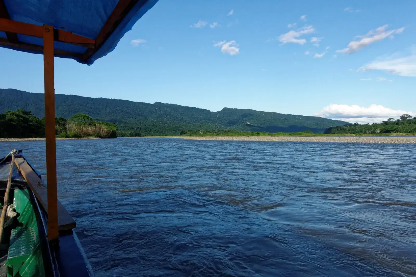
The Pantiacolla Mountains are a long, forest-covered ridge on the eastern edge of the Andes, in the Manu area of Madre de Dios. There is no gate, viewpoint or ticket office: you see them from the Alto Madre de Dios river and from trails that climb into the cloud forest above it, usually as part of a multi-day Manu programme. Plan on a guide, a boat and at least a few days; the range is a setting more than a single sight.
Map
What the Pantiacolla Mountains are
The Pantiacolla range is a forested ridge on the eastern foothills of the Andes, in the Madre de Dios region of south-eastern Peru. It is not a snow peak or a famous summit: the heights involved are modest by Andean standards, with one geographic database giving the range an elevation of about 1,300 m, a figure that should be taken as approximate. What makes it distinctive is what covers it. The slopes are clothed in cloud forest and lowland rainforest, and the ridge stands as a green wall above the river plain.
Visitors meet it as part of the wider Manu National Park landscape rather than as a destination in its own right. It lies on the Manu side of the region, in the foothills where the road from the highlands has already given way to river travel. The name is also used for a plateau and for a stream, so you will see it on several maps with slightly different meanings. Ask your operator which part of the range your itinerary actually refers to.
Why it matters
Its value is ecological. The foothills between roughly 350 m and 1,200 m, which is the band covered by the forest around the main lodge in the area, hold lowland species at the bottom and cloud-forest species higher up, so a short walk uphill changes the birds, the plants and the air. Primates, peccaries and many bird species are described for the lowest trails, while the upper slopes are quieter and cooler.
The ridge also carries a layer of legend. Explorers have for decades searched the area between the Alto Madre de Dios and the Urubamba basin for Paititi, the lost Inca refuge of Amazonian folklore. No such city has been confirmed, and some formations nearby, such as the hills called the Pantiacolla or Paratoari pyramids, are described by many sources as natural. Treat any claim of a discovery as unproven, and enjoy the story for what it is.
How you see it from the river
The best views come from the boat. Between the small settlements on the Alto Madre de Dios, the ridge appears across a wide, gravel-banked river, with forest running right to the water. A boat trip upstream or downstream gives a better sense of scale than any trail, because the forested slope fills the horizon for long stretches.
Time of day changes the picture. Early morning often brings mist along the lower slopes, and the light is soft on the water. By midday the cloud may build over the ridge, and the afternoon sun picks out the crests. Bring binoculars: the river edge is also where capybaras, herons and egrets are most likely to be seen, and the boat is a moving hide.
Getting there from Cusco
Reaching the range means entering the Manu area. The usual overland route follows the Manu road from Cusco over the highlands and down through cloud forest to the river settlements of the upper Madre de Dios, where a boat takes over. Operators commonly describe it as a two-day journey by road and boat; the details are in Cusco to Manu. Some programmes use a short flight to the lowland airstrip at Boca Manu, followed by several hours of boating up the river.
There is no public transport to the forest lodges, and the road can be closed by landslides in the wet season, so build a spare day into the plan. Independent travellers can reach the road-end villages, but the ridge itself is visited through lodges and licensed operators, which also deal with permits where they apply.
Trails and what to expect
Walks into the ridge are organised from lodges and camps in the foothills. Trail systems typically include flat paths at around 350 m, with the highest wildlife diversity, and longer climbs of several kilometres that reach roughly 900 m into cloud forest, with views back towards the Andes. Expect mud, roots, humidity and insects, and an early start: most animals are active at dawn.
Guides lead every walk. Their value is in spotting birds, monkeys and tracks you would walk past, and in keeping you on the trail. Wildlife is never guaranteed, and many visitors see mostly birds, plants and the forest itself. For food on the trip, what to eat in the Amazon explains what lodge kitchens usually serve, and the water arrangements should be confirmed with the operator.
Best time to go
The drier months, roughly May to October, are the main season, with more reliable road travel, lower rivers and more sun on the ridge. The wetter months, roughly November to April, bring heavy rain, higher water and a greater risk of delays on the mountain road. Cloud forest stays damp all year, so a rain jacket is useful whatever the month.
Temperatures at the river are warm and humid, while nights in the upper cloud forest are cooler. The range has no single peak season for scenery, but dry-season mornings give the clearest views of the ridge. Confirm road and river conditions with your operator before you leave, since both can change the programme.
Health, safety and altitude
The range is low enough that altitude sickness is not the issue here, although the journey from Cusco crosses high passes first. The real concerns are remoteness and the lowland climate: mosquito-borne diseases, limited medical help and slow evacuation. Talk to a doctor or travel clinic well ahead, and read health and vaccines before you book.
Take travel insurance that covers remote areas and evacuation, as described in travel insurance. On the water, wear the life jacket if provided, and keep cameras in a dry bag. Do not leave the trail alone. Parts of the wider region are home to communities who live in voluntary isolation, and no visit should ever try to find or approach them.
Who it suits and what to combine it with
This is a good fit for birdwatchers, photographers who like rivers and forest, and travellers who want a calm, scenic part of Manu rather than a checklist of species. It is less suited to anyone expecting a single landmark, to people with limited mobility, or to those short of time.
Combine it with the other parts of a Manu programme, such as the cloud-forest road, the lowland river and the cultural zone. If your priority is the easiest introduction to the rainforest, Tambopata near Puerto Maldonado is more convenient; Amazon: where to go compares the options. Whether the effort pays off is covered in is the Amazon worth it.
Frequently asked questions
Can I visit the Pantiacolla Mountains without a tour?
Not in any practical way. The area is reached by a long road and river journey with no public transport to the lodges, and visits to the reserved parts of Manu need an authorised operator. See Manu National Park for how access works.
How high are the Pantiacolla Mountains?
They are a modest range: one geographic database gives about 1,300 m for the range, and trails from the foothill lodges reach roughly 900 m. The figures vary by source, so treat them as approximate.
Is there a viewpoint or an entrance ticket?
No single one that is widely used. Most people see the ridge from the boat on the river or from lodge trails, and any fees are part of the operator's programme. Ask what is included.
How many days do I need?
The range is seen as part of a Manu trip, which is normally at least five days from Cusco. A shorter visit is possible only with a flight to the lowlands, and still leaves little time for walking.
Is the Pantiacolla ridge where the lost city of Paititi is?
Explorers have searched the region for decades, but no lost city has been confirmed, and some nearby formations are considered natural. Treat claims of discovery with caution.
Will I see jaguars or other big animals?
Large cats are rarely seen. More likely sightings are birds, several monkey species, capybaras and peccaries, with luck. No operator can promise a particular animal.
Do I need vaccines for the area?
Lowland Manu carries mosquito-borne and other tropical health risks, and advice depends on your own history. Speak to a doctor or travel clinic well before departure and read health and vaccines.